

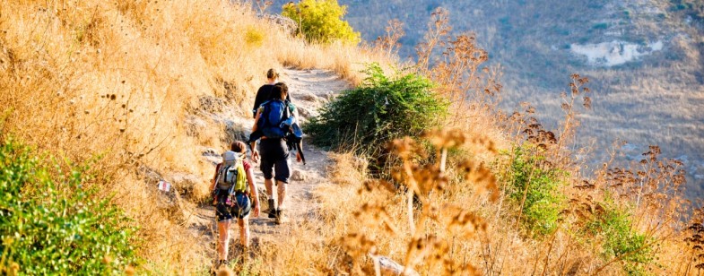
Though it appears to be a small and modest country, Israel offers some of the most beautiful scenes created in nature. The wild rivers of the Galilee and Golan and the deep canyons of the Judean Desert and the Negev craters, blended with Israel’s unique cross-section of world history, create a unique experience that travelers and nature lovers can’t find anywhere else on the globe.
Israel’s trails are marked really well, and easy to follow. Marking is usually a red/blue/green/black strip between two white strips. A three color strip is a special trail.
Special trails
The long Israel National Trail (INT), which connects Mt. Hermon, in the upper Galilee with Eilat, at the southernmost tip of Israel. But since most of us don’t have the time to cross Israel on foot from end to end, day hikes or weekend hikes on parts of the trail can be just as enjoyable. Short trails, for hikes lasting just a few days, are abundant in Israel.
Other special trails: 70-150km long
The Golan trail – http://www.golantrail.com/
The Jesus trail – http://www.jesustrail.com/
The Haifa trail – http://www.haifatrail.com/
The most suitable locations for long treks are in the desert. Yet, as you will learn from the information below, that great short hikes can be carried out in more populated regions.
Transportation
There are two major problems with some of the trails in Israel, especially in the south. First, many of the trails aren’t loop trails; they don’t end at the starting point, so it may be difficult to get back to your vehicle. Second, due to the remoteness of the trailheads, there’s a chance your car could be broken into, or even stolen, by the time you get back. It is better to consult your hostel owner or reception to get more information about the trail and how to land there.
Public buses are a great solution to these problems. Many trails can be planned to start and end on main roads, where bus stops are found. Israel has an excellent public transportation system, so bus lines are a convenient way to travel to and from the trail. Another advantage is not having to drive after a tiring hike.
Note: there is no public transportation on Saturdays, but you can plan your trip to begin on Friday and end on Saturday night or Sunday, when buses return to the roads. And if you’re with a group of people and don’t want to take a bus, renting a taxi can be another worthwhile option.
Planning your trek
A few years ago, the project of printing maps showing all of Israel’s trails was completed. There are 20 large-scale (1:50,000) topographical maps that cover the entire country. The maps show all of the trails, as well as trail markings. They’re not cheap, but a substantial part of their cost goes toward the maintenance and marking of the trails.
The maps are in Hebrew only, but non-Hebrew speakers can use a larger-scale English-language road map to decipher the names of cities and towns. The maps can be ordered online at http://ecom.gov.il/Mapi/homepage_en.aspx?category=13&language=en-US. You can also buy the maps in several nature reserves and national parks, as well as in book shops and travel shops (e.g. Lametayel, Rikushet, Maslul).
A very helpful English translation of the hiking maps’ key can be downloaded from the Jesus Trail website here.
Regions and Trails
Below you can find a list of hikes and trek sections, listed according to the various regions in Israel. Each row details a single section, which can be hiked in one day (more or less). You can hike only one section or connect several sections into a long hike. During the planning phase of your hike, use the topographical maps in order to determine your trek’s layout according to section.
More detailed information on the hikes below can be found online or on travel guidebooks.
Many hikes are named according to the river/stream (e.g. Wadi) which you walk in. Most of the streams (Wadis) in Israel are dry, mainly in the desert.
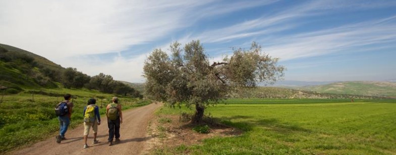
Golan heights
It doesn’t matter if you’re looking for an hour walk or a 3 day trek, the Golan Heights is a classic destination, offering huge range of trails with a diverse landscape and an easy access to most of the trails.
As you walk around , it’s very usual to meet the following – Running water streams, beautiful waterfall, ancient volcanos, Druze villages , ancient forest, Herds of cows and goats, wild boars, gazelles and foxes , Vineyard, orchids of apples and cherries – all them are waiting for you in hart of the Golan – its trails…
When to come – every season has its benefits…In Winter time its muddy and wet…, spring time is ideal for blooming flowers, and in summer it’s the real place to escape from the hit and have a dip in the cold water…
From north to south
Hermon stream
From nimrod fort to the Hermon stream
Hazuri stream to nimrod fort
Saar stream
– “nimrodem” – from nimrod to mount Odem (part of the Golan trail)
Odem –valley of tears – mount bental ( part of Golan trail)
Gilabun stream
Zavitan stream
Yahudia stream
Gamla nature reserve
Meitzar stream
This is a short list out of the many hiking options in the Golan. For any info or help with planning your hikes in the Golan pleas contact on of the hostels in the Golan and we will be very happy to help…
Haifa and the Carmel
Mount Carmel area is wonderful for a multi-day trek. The trek combines visits to towns and villages with the pleasure of being surrounded by the flora and fauna of the Carmel. The best hiking season is between October and May; February to April is especially nice because of the beautiful spring blossoms.
Note that many trails start and end in the city of Haifa, and are thus easily accessed by public transportation.
Sections:
– University of Haifa – Wadi Nadar – Ein Kedem – Wadi Galim – Tirat Carmel
– University of Haifa – Wadi Nadar – Wadi Galim – University of Haifa
– Moria Blvd. – Lotus St. – Wadi Siach – El-Kababir – Moria Blvd.
– Ha’em Garden – Wadi Lotem – Western Carmel – Ha’yam Rd. – Ha’em Garden
– Kerem Maharal – Wadi Me’arot – Ein Hod – Ezba cave
– Ezba cave – Wadi Oren – Wadi Spunim – Tirat Carmel
– Ezba cave – Wadi Oren – Mt. Shokef. – Ussefiya
– Ussefiya – Wadi Yagur – Yagur – Giva’at Neshser
– Ussefiya – Hirbet Kali’a – Muchraka – Yoqne’am
– Mt. Shokef mt. – Mt. Arkan – Kdumim mines – Wadi Kelah – Wadi Galim – Tirat Carmel
– Kdumim mines – Kelah cave – Univercity of Haifa
Sde Boker and the Negev Mountains
The area lying south of the Sde Boker Campus and the Tzin River provides plentiful hiking opportunities, including peaks with observation points, and green springs in the heart of the desert. The main access points to the trails are at the Sde Boker Campus and the ancient city of Avdat. Longer hikes can be planned to start or end in Mitzpe Ramon. These access points can be easily reached from Be’er Sheva by bus.
Ein Akev is one of the most remarkable natural springs of the Negev. Even in the middle of summer, it pours forth water to create a cool and deep pool. Hod Akev is a great observation point; longer trips can take you to green Ein Zik and Ein Chava.
The Ramon Crater (Maktesh) boasts a breathtaking view and is the most spectacular geological sight in the country. There are lots of amazing hikes in and around the crater. A detailed map of hiking routes in the crater can be obtained for free in the Ramon crater visitor center.
Again, because of the extreme heat in the Negev, the recommended hiking season is from October to May.
Sections:
– Ein-Avdat – Wadi Havarim – Ein-Avdat
– Ben Guryon campus – Hod Akev – Ein Akev – Ma’ale Divshon – Ben Guryon campus
– Ein Akev – Upper Ein Akev – Avdat
– Ein Akev – Upper Ein Akev – Ein Shviv/Zik
– Ein Shviv/Zik –Thirsty snake’s Ma’ale – Ein Sharav – Ma’ale Sharav – Hirbet Sharav
– Hirbet Sharav – Cracks’ site – Wadi Hava – Ein Hava – Hava cisterns
– Hava cisterns – Ma’ale Machmal – Mitzpe Ramon
– Ein Yorke’am – The Large Crater (Mt. Karbolet) – Wadi Afran
– Wadi Afran – Wadi Zin –Ben Guryon Campus
Judean Desert and the Dead Sea
The Judean Desert lies along the southern slopes of the Hebron Mountains’ anticline and descends all the way to the Dead Sea. The desert is furrowed by desert rivers (Wadis) cutting their way eastward towards the Dead Sea. The wadis create deep and twisting canyons that conceal springs, vegetation and wildlife.
At its eastern tip, the desert is actually a plateau that stands about 200 meters above the Dead Sea, and then suddenly drops to the shore, creating a chain of cliffs. One of the beautiful things encountered while traveling in the Judean Desert is the combination of walking in the canyons, and then reaching amazing viewpoints at cliff tops. Another option is to start at the Dead Sea, ascend through one of the canyons or ancient ascents to the top of the cliffs, and then return to the shore via a different canyon.
Even if you focus solely on Ein Gedi, right at the edge of the Dead Sea, you can spend a few days exploring just that area. In the popular Ein-Gedi nature reseve (where wadi David and wadi Arugot are located), there are many trails that people seldom visit. These wadis contain flowing water all year round – and can be hiked even during the blazing summer days.
There are all sorts of hikes in the Judean Desert. Climbing and visiting Masada is a must. but you may also consider viewing the impressive Masada from the adjacent mountain, Mount Elazar. When winter comes, there is a pool of water at Ein Mishmar at the bottom of a formidable cliff. From another ridge called Tamroor Cliff, you can take an undemanding hike that includes a running stream (365 days) and 2 natural springs, and ends at the hotel area in Ein Bokek.
Access to the trails is possible from Highway 90 (Dead Sea Highway), Highway 31 from Arad, and Highway 25 from Dimona. The recommended hiking season is from November to May.
Floating in the Dead Sea is an experience not to be passed on. Don’t be surprised when you find you can’t swim, as the moment you enter the water, your body naturally floats to the top due to the high salt and mineral content in the water. Until you experience it, you will have a hard time believing that you can literally float on top of the water and actually read a newspaper without it getting wet. It is almost impossible to drown in the Dead Sea but in any case don’t put your head into the water.
Sections:
– Ein-Gedi field school – Ishay observatory – Wadi David – Ein-Gedi
– Ein-Gedi – Wadi Arugot – Ma’ale Bnei Hamoshavim – Ein-Gedi observatory – Ma’ale Ein-Gedi
– Ein-Gedi – Wadi Arugot –Ma’ale Ha’isiyim – Hever Heights – Mt. Zruya – Ma’ale Zruya – Ein-Gedi
– Hever Heights – Ma’ale Mishmar – Ein Mishmar
– Rd. 90 – Wadi Mishmar canyon – Ein Mishmar – Ma’ale Ze’elim – Rd. 90
– Ein Mishmar – Ma’ale Namer – Wadi Ze’elim – Rd. 90
– Ein Mishmar – Ma’ale Namer – Birket Zfira
– Birket Zfira – Arad
– Birket Zfira – Mt. Na’ama – Ma’ale Anava – Rd. 90
– Birket Zfira – Mt. Na’ama – Massada
– Massada – Ma’ale Elazar – Mt. Elazar – Mt. Kana’im
– Massada – Mt. Elazar – Ma’ale Rahaf/Mor – Rd. 90
– Ma’ale Mor/Rahaf – Ma’ale Bokek – Ein Bokek
– Arad – Hirbet Uza – Wadi Heimar – Rd, 258
– Rd. 258 – Wadi Heimar – Neve Zohar
– Arad – Wadi Tabiya – Rosh Zohar – Zohar observatory – Wadi Abuv – Hatrurim junction
– Neve Zohar – Wadi Prazim – Amiaz plain
– Amiaz plain – Mt. Sodom – Rd. 90
– Amiaz plain – Wadi Azgad – Wadi Ashalim – Amiaz Plain
– Rd. 25 – Wadi Peres – Arava junction
– Rd. 25 – Wadi Zafit – Arava junction
– Rd. 25 – Wadi Zafit – Ma’ale Hazera – The Small Crater – Rd. 90
Eilat Mountains
Eilat Mountains are the modest but worthy version of the “Sinai High Mountains,” and are actually an extension of that mountain range. Eilat Mountains are one of the most beautiful mountainous regions of Israel, and if you haven’t taken some day hikes there, drop everything and go now.
The mountains are over 800 meters (2500 feet) high, and are rich in colors, thanks to their diverse geological makeup – dark granite alongside light limestone. There are amazing canyons, as well as wonderful peaks, from which one can see not only the city of Eilat, but four countries: Israel, Egypt, Jordan, and Saudi Arabia.
The climb to Mt. Shlomo, which rises 705 meters above Eilat, is an amazing experience. The spring of Ein Netafim lies at the bottom of a beautiful canyon. The hike from Wadi Gishron to the Gishron Cliffs takes you along the knife-edge of the mountain range. All of these trails are easily accessible from Highway 90 or Highway 12 by bus or by taxi.
If you’re on vacation in Eilat, we highly recommend taking a long day trip on one of the trails through the Eilat Mountains. Another good option is planning a two or three-day trip that ends in a cozy Eilat hostel!
Due to the extreme summer heat in the south, the recommended hiking season is from November to May.
Sections:
– Eilat SPNI field school – Mt. Zfahot – Gishron cliffs – Wadi Gishron – Rd. 12
– Rd. 12 – Mt. Shlomo – Mt. Yehoram – Ein Netafim – Rd. 12
– Rd. 12 – Mt. Shlomo – Wadi Bat-Sheva – Wadi Netafim – Mt. Shachmon – Eilat
– Rd. 12 – Ein Netafim – Wadi Netafim – Guy Avud – Mt. Shechoret – Shechoret canyon – Rd. 90
– Rd. 90 – Shechoret canyon – Wadi Amir – Amram pillars – Rd. 90
– Rd. 90 – Amram pillars – Ma’ale Amram – Amram observatory – The hidden valley – Rd. 90
– Amram observatory – Wadi Raham – Wadi Shani – The Red canyon – Mt. Uziyahu – Rd. 12
– Timna visitor center – Mt. timna – Solomon’s Pillars – Timna lake
– Timna lake – Ma’ale Berech – Mt. Berech
– Mt. Berech – Timna cliffs – Timna prak visitor center
This article and pictures were provided by by Guy Shachar, hiking expert and an experienced backpacker – www.guyshachar.com
Disclaimer: Hiking is an extreme activity which holds several dangers, and therefore should be carefully planned and performed in a responsible manner (especially when hiking in the desert). The information stated above is just a general recommendation and does not hold any liability to any damage which might occur to people using it.